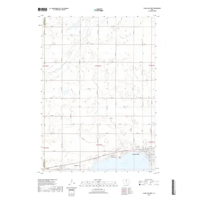
2018 Map of Clear Lake West
USGS Topo · Published 2018About this map
The settlement of Ventura sits on the western shore of Clear Lake, marking the transition from the lake's recreational edge to the agricultural heartland of North Central Iowa. This 2018 survey illustrates a landscape defined by water and grid-iron roads, where the Winnebago River meanders across the northern reaches and Willow Cr drains toward the lake. The terrain is notably punctuated by glacial features and localized depressions, with Relly Point extending into the water near the lake's western narrows. Genealogists and local historians can locate the Grant Cem positioned near the river, while the modern road network includes Buddy Holly Pl, a tribute to the area's cultural history. The map also delineates the county boundary between Hancock and Cerro Gordo counties, tracing a line through a mix of wetlands and productive farmland.
Find a feature on this map
73 named features on this map. Tap any name to fly to it.
Don’t see what you’re looking for? This feature index may not catch every label — zoom into the map to look around manually.
Map Details
Editions of this 2018 Clear Lake West Map
This is the sole edition of this map. No revisions or reprints were ever made.
Other maps of this area

1954 · Mason City
USGS Topo · 1:250,000

1957 · Mason City
USGS Topo · 1:250,000

1958 · Mason City
USGS Topo · 1:250,000

1972 · Clear Lake West
USGS Topo · 1:24,000

1972 · Fertile
USGS Topo · 1:24,000

1972 · Burchinal
USGS Topo · 1:24,000
1972 · Clear Lake East
USGS Topo · 1:24,000
1972 · Fertile SE
USGS Topo · 1:24,000

1972 · Pilot Knob
USGS Topo · 1:24,000
1972 · Ventura Heights
USGS Topo · 1:24,000