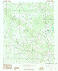
1982 Map of Clear Pond
USGS Topo · Published 1983About this map
The Little Salkehatchie River and its larger counterpart, the Salkehatchie River, define the watery geography of this Bamberg County landscape in the early 1980s. The terrain is characterized by numerous swampy basins known locally as bays, including Sutton Bay and Ben Rice Bay, which interrupt the low-lying woodlands. A network of rural churches and family-named cemeteries serves as the primary evidence of long-standing community settlement patterns, with landmarks like Union Ch near the village of Springtown and Williams Chapel further south. Educational and spiritual life are anchored by sites such as the Andrew Jackson Academy and Macedonia Ch. Small water bodies like Clear Pond and Ocean Pond dot the drainage basins, while various branches like Colston Branch and Indian Camp Branch feed into the river system, illustrating the intricate hydrology of the South Carolina Coastal Plain.
Find a feature on this map
28 named features on this map. Tap any name to fly to it.
Don’t see what you’re looking for? This feature index may not catch every label — zoom into the map to look around manually.
Map Details
Editions of this 1982 Clear Pond Map
This is the sole edition of this map. No revisions or reprints were ever made.
Other maps of this area

1919 · Olar
USGS Topo · 1:62,500

1919 · Bamberg
USGS Topo · 1:48,000

1919 · Lodge
USGS Topo · 1:62,500

1920 · Lodge
USGS Topo · 1:48,000

1920 · Bamberg
USGS Topo · 1:62,500

1920 · Orangeburg
USGS Topo · 1:48,000

1921 · Orangeburg
USGS Topo · 1:62,500

1921 · Lodge
USGS Topo · 1:62,500

1943 · Olar
USGS Topo · 1:62,500

1943 · Lodge
USGS Topo · 1:62,500