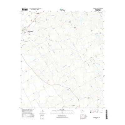
2016 Map of Cleburne East
USGS Topo · Published 2016About this map
Cleburne and Keene anchor the northwestern corner of this Johnson County landscape, where urban street grids transition into a network of ranch roads and small aviation strips. The eastern reaches of Cleburne are dominated by local landmarks including Cleburne Memorial Park and significant burial grounds such as Rose Hill Cem and Oak Cem. Beyond the city limits, the terrain is defined by the winding course of Mustang Cr and the several forks of the Chambers Creek system, including the Middle Fork S Fork Chambers Cr. Rural life here is characterized by a series of private airstrips, from the Embry Ranch Airport to the Thomas Flying Field, reflecting the region's relationship with private flight. Smaller communities and crossroads like Coyote Flats, Oak Hill, and Cuba are connected by a dense lattice of county roads, such as Co RD 415, illustrating the persistent settlement patterns of the Texas blackland prairies.
Find a feature on this map
102 named features on this map. Tap any name to fly to it.
Don’t see what you’re looking for? This feature index may not catch every label — zoom into the map to look around manually.
Map Details
Editions of this 2016 Cleburne East Map
This is the sole edition of this map. No revisions or reprints were ever made.
Other maps of this area

1891 · Cleburne
USGS Topo · 1:125,000

1894 · Cleburne
USGS Topo · 1:125,000

1924 · Cleburne 3-B
USGS Topo · 1:48,000

1927 · Blum
USGS Topo · 1:62,500

1954 · Dallas
USGS Topo · 1:250,000

1958 · Dallas
USGS Topo · 1:250,000

1960 · Keene
USGS Topo · 1:24,000

1960 · Cleburne East
USGS Topo · 1:24,000
1961 · Cleburne West
USGS Topo · 1:24,000

1961 · Alvarado
USGS Topo · 1:24,000