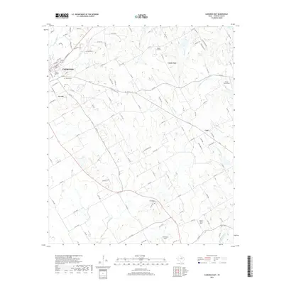
2019 Map of Cleburne East
USGS Topo · Published 2019About this map
Cleburne anchors the western edge of this landscape, where the residential grids of the city transition into the agrarian expanses of eastern Johnson County. The area is defined by a network of drainage systems, including Mustang Cr and the various forks of S Fork Chambers Cr, which dictate the placement of rural homesteads and historical burial grounds. Several small, private aviation sites such as Hodges Air Field and the Cow Pasture Airport are scattered across the terrain, reflecting the modern rural-industrial character of North Texas. For the local historian, the map preserves the exact locations of significant community sites like Faulkenbury Cem and Morrow Cem, along with the small settlements of Cuba and Coyote Flats. This documentation of the land east of the county seat highlights how the region's ranching roots persist alongside twentieth-century infrastructure.
Find a feature on this map
114 named features on this map. Tap any name to fly to it.
Don’t see what you’re looking for? This feature index may not catch every label — zoom into the map to look around manually.
Map Details
Editions of this 2019 Cleburne East Map
This is the sole edition of this map. No revisions or reprints were ever made.
Other maps of this area

1891 · Cleburne
USGS Topo · 1:125,000

1894 · Cleburne
USGS Topo · 1:125,000

1924 · Cleburne 3-B
USGS Topo · 1:48,000

1927 · Blum
USGS Topo · 1:62,500

1954 · Dallas
USGS Topo · 1:250,000

1958 · Dallas
USGS Topo · 1:250,000

1960 · Keene
USGS Topo · 1:24,000

1960 · Cleburne East
USGS Topo · 1:24,000
1961 · Cleburne West
USGS Topo · 1:24,000

1961 · Alvarado
USGS Topo · 1:24,000