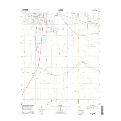
2015 Map of Cleveland
USGS Topo · Published 2015About this map
Cleveland serves as the focal point of this Mississippi Delta landscape, where the campus of Delta State University and the town's street grid meet a network of agricultural roads and bayous. The town is flanked by smaller settlements like Boyle to the south and Halstead to the east, illustrating the dense placement of communities in this fertile region. The presence of South Illinois Central Avenue marks the importance of the rail corridor in shaping the local economy. Beyond the urban center, the land is defined by a complex drainage system including Peach Bayou, Jones Bayou, and the winding Big Sunflower River on the eastern edge. Genealogists will find several burial sites noted across the quadrangle, such as Poplar Grove Cemetery, Fairview Cemetery, and Christian Cemetery, providing specific points of interest for local history and family research.
Find a feature on this map
126 named features on this map. Tap any name to fly to it.
Don’t see what you’re looking for? This feature index may not catch every label — zoom into the map to look around manually.
Map Details
Editions of this 2015 Cleveland Map
This is the sole edition of this map. No revisions or reprints were ever made.
Other maps of this area

1931 · Drew
USGS Topo · 1:48,000

1934 · Cleveland
USGS Topo · 1:62,500

1935 · Mound Bayou
USGS Topo · 1:62,500

1939 · Pace
USGS Topo · 1:62,500

1939 · Choctaw
USGS Topo · 1:62,500

1940 · Cleveland
USGS Topo · 1:62,500

1953 · Greenwood
USGS Topo · 1:250,000

1956 · Greenwood
USGS Topo · 1:250,000
1966 · Merigold
USGS Topo · 1:24,000

1966 · Cleveland
USGS Topo · 1:24,000