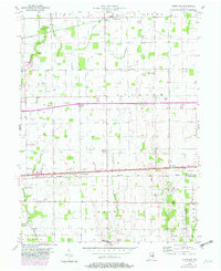
1956 Map of Cleveland
USGS Topo · Published 1982About this map
The National Road and the Conrail railroad form a dense corridor of 20th-century development through this portion of Hancock and Rush counties. The small settlements of Cleveland and Stringtown are concentrated along this east-west axis, illustrating how transportation routes dictated the growth of rural Indiana. To the north, Willow Branch serves as a secondary focal point, while the southern reaches near Westland retain a more dispersed agricultural character punctuated by numerous family and community burial grounds, such as Hinchman Cem and Caldwell Cem.
Find a feature on this map
38 named features on this map. Tap any name to fly to it.
Don’t see what you’re looking for? This feature index may not catch every label — zoom into the map to look around manually.
Map Details
Editions of this 1956 Cleveland Map
2 editions found
Other maps of this area

1952 · Greenfield
USGS Topo · 1:24,000

1952 · Fountaintown
USGS Topo · 1:24,000

1952 · Ingalls
USGS Topo · 1:24,000

1953 · Pendleton
USGS Topo · 1:24,000

1953 · Cincinnati
USGS Topo · 1:250,000

1956 · Cleveland
USGS Topo · 1:24,000

1956 · Morristown
USGS Topo · 1:24,000

1957 · Cincinnati
USGS Topo · 1:250,000
1960 · Carthage
USGS Topo · 1:24,000
1960 · Knightstown
USGS Topo · 1:24,000