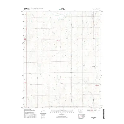
2016 Map of Cleveland
USGS Topo · Published 2016About this map
Cleveland remains a quiet hub of activity in this rural corner of Kingman County, defined by a grid of agricultural section lines and the meandering path of the South Fork Ninnescah River. The landscape is a textbook example of the Public Land Survey System, with roads like Cleveland Rd and several numbered streets such as SW 20 St and SW 100 St strictly following the township and range boundaries of t28s r8w and surrounding sections. Local history is anchored at the Cleveland Cem, located just west of the town center. To the north, the terrain softens around Mekenna Lake, providing a break in the vast stretches of farmland that dominate the quadrangle. This 2016 survey captures the enduring rural structure of the Kansas plains, where the late-twentieth-century water management of small lakes meets a road network established over a century prior.
Find a feature on this map
20 named features on this map. Tap any name to fly to it.
Don’t see what you’re looking for? This feature index may not catch every label — zoom into the map to look around manually.
Map Details
Editions of this 2016 Cleveland Map
This is the sole edition of this map. No revisions or reprints were ever made.
Other maps of this area

1889 · Anthony
USGS Topo · 1:125,000

1891 · Anthony
USGS Topo · 1:125,000

1892 · Kingman
USGS Topo · 1:125,000

1894 · Kingman
USGS Topo · 1:125,000

1955 · Pratt
USGS Topo · 1:250,000

1959 · Pratt
USGS Topo · 1:250,000

1967 · Kingman NW
USGS Topo · 1:24,000
1967 · Alameda
USGS Topo · 1:24,000

1967 · Cleveland
USGS Topo · 1:24,000
1967 · Kingman
USGS Topo · 1:24,000