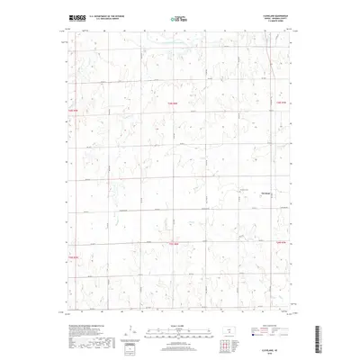
2018 Map of Cleveland
USGS Topo · Published 2018About this map
Cleveland sits on the eastern edge of this Kingman County landscape, serving as a primary point of settlement in a region defined by its complex network of prairie waterways. The South Fork Ninnescah River flows across the northern reaches, while numerous tributaries like Wild Horse Cr and Wild Run Cr carve through the sectioned agricultural plots. For those tracing family ties to the area, the Cleveland Cem is a significant landmark located just northwest of the town site. The map illustrates a strictly organized grid of local roads, such as Cleveland Rd and Ball Park Rd, which follow the township and range lines established by the Public Land Survey System. This layout reveals the enduring influence of 19th-century land division on modern Kansas geography, where small creek valleys like Hunter Cr and Red Cr provide the only breaks in the geometric precision of the plains.
Find a feature on this map
32 named features on this map. Tap any name to fly to it.
Don’t see what you’re looking for? This feature index may not catch every label — zoom into the map to look around manually.
Map Details
Editions of this 2018 Cleveland Map
This is the sole edition of this map. No revisions or reprints were ever made.
Other maps of this area

1889 · Anthony
USGS Topo · 1:125,000

1891 · Anthony
USGS Topo · 1:125,000

1892 · Kingman
USGS Topo · 1:125,000

1894 · Kingman
USGS Topo · 1:125,000

1955 · Pratt
USGS Topo · 1:250,000

1959 · Pratt
USGS Topo · 1:250,000

1967 · Kingman NW
USGS Topo · 1:24,000
1967 · Alameda
USGS Topo · 1:24,000

1967 · Cleveland
USGS Topo · 1:24,000
1967 · Kingman
USGS Topo · 1:24,000