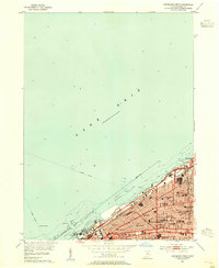
1953 Map of Cleveland North
USGS Topo · Published 1955About this map
Lake Erie defines the northern edge of this urban survey, where the East Basin and West Basin meet at the mouth of the Cuyahoga River. The map details the dense infrastructure of Cleveland just after the mid-century, including the massive rail networks of the New York Central and Pennsylvania railroads that serviced the waterfront. Inland, the map reveals a community anchored by institutional landmarks such as Fenn College, Polyclinic Hospital, and numerous neighborhood schools like Addams High Sch and Sowinski Sch. Maritime and civic life intersect at the shoreline, where the Lakefront Airport and the Stadium sit adjacent to the harbor's breakwater and various industrial utilities including the Waterworks Intake. These features illustrate the city's role as a major Great Lakes industrial and transportation hub during its post-war peak.
Find a feature on this map
49 named features on this map. Tap any name to fly to it.
Don’t see what you’re looking for? This feature index may not catch every label — zoom into the map to look around manually.
Map Details
Editions of this 1953 Cleveland North Map
This is the sole edition of this map. No revisions or reprints were ever made.
Other maps of this area

1901 · Euclid
USGS Topo · 1:62,500

1902 · Berea
USGS Topo · 1:62,500

1903 · Cleveland
USGS Topo · 1:62,500

1903 · Euclid
USGS Topo · 1:62,500

1904 · Berea
USGS Topo · 1:62,500

1950 · Cleveland
USGS Topo · 1:250,000

1953 · Shaker Heights
USGS Topo · 1:24,000

1953 · East Cleveland
USGS Topo · 1:24,000
1953 · Cleveland South
USGS Topo · 1:24,000
1953 · Lakewood
USGS Topo · 1:24,000