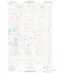
1953 Map of Cleveland SE
USGS Topo · Published 1978About this map
Moon Lake and a dense network of prairie wetlands define this corner of Stutsman County during the mid-20th century. The landscape is a complex mosaic of glacial depressions, including the elongated waters of Sinclair Slough and Runner Slough. These features speak to the hydrologic character of the Missouri Coteau, where drainage is often internal and water bodies like Olson Slough and Jaff Slough expand or contract with the seasons.
Find a feature on this map
18 named features on this map. Tap any name to fly to it.
Don’t see what you’re looking for? This feature index may not catch every label — zoom into the map to look around manually.
Map Details
Editions of this 1953 Cleveland SE Map
2 editions found
Other maps of this area

1896 · Jamestown
USGS Topo · 1:125,000

1951 · Eldridge NW
USGS Topo · 1:24,000

1952 · Jud NW
USGS Topo · 1:24,000

1952 · Eldridge SW
USGS Topo · 1:24,000

1953 · Jamestown
USGS Topo · 1:250,000

1953 · Cleveland SE
USGS Topo · 1:24,000

1953 · Cleveland
USGS Topo · 1:24,000

1953 · Cleveland SW
USGS Topo · 1:24,000

1954 · Cleveland NW
USGS Topo · 1:24,000

1956 · Jamestown
USGS Topo · 1:250,000