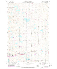
1953 Map of Cleveland
USGS Topo · Published 1978About this map
Cleveland and Windsor anchor the southern reaches of this central North Dakota landscape, situated along the vital corridor of the Burlington Northern railroad. The terrain is characterized by a dense network of prairie potholes and sloughs, including Bair Slough and Runner Slough, which reflect the region's glacial legacy. Larger water bodies like Moon Lake, Deer Lake, and Valley Spring are interspersed among the undulating hills, with Terpena Hill providing a notable topographic high point.
Find a feature on this map
15 named features on this map. Tap any name to fly to it.
Don’t see what you’re looking for? This feature index may not catch every label — zoom into the map to look around manually.
Map Details
Editions of this 1953 Cleveland Map
2 editions found
Other maps of this area

1896 · Jamestown
USGS Topo · 1:125,000

1900 · Pingree
USGS Topo · 1:125,000

1900 · Pingree
USGS Topo · 1:62,500

1951 · Eldridge NW
USGS Topo · 1:24,000

1952 · Pingree SW
USGS Topo · 1:24,000

1952 · Eldridge SW
USGS Topo · 1:24,000

1952 · New Rockford
USGS Topo · 1:250,000

1953 · Jamestown
USGS Topo · 1:250,000

1953 · Cleveland SE
USGS Topo · 1:24,000

1953 · Cleveland
USGS Topo · 1:24,000