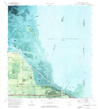
1971 Map of Clewiston North
USGS Topo · Published 1976About this map
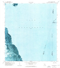
Clewiston sits at the southern gateway to Lake Okeechobee in this 1970s orthophotomap, showing the town's grid and industrial infrastructure alongside the massive Herbert Hoover Dike. The map illustrates the specialized water-based landscape of the Florida Everglades, where an Airboat Trail winds through the marsh toward Observation Island and Turners Cove. On the landward side of the dike, the community infrastructure is clearly visible, including the High Sch, Hendry Hosp, and the Ridgelawn Cem near the Rim Canal. Small settlements like Shawnee, High Haven, and Liberty Point appear as distinct pockets of development within the surrounding agricultural and swamp lands. The transition from the open waters of the lake to the islands like Grass Island and Boomers Island highlights the intricate, shifting shoreline of this inland sea.
Find a feature on this map
25 named features on this map. Tap any name to fly to it.
Don’t see what you’re looking for? This feature index may not catch every label — zoom into the map to look around manually.
Map Details
Editions of this 1971 Clewiston North Map
3 editions found
Other maps of this area

1956 · West Palm Beach
USGS Topo · 1:250,000

1957 · West Palm Beach
USGS Topo · 1:250,000

1958 · West Palm Beach
USGS Topo · 1:250,000

1970 · Lake Harbor
USGS Topo · 1:24,000

1970 · Moore Haven
USGS Topo · 1:24,000

1970 · Clewiston South
USGS Topo · 1:24,000

1970 · La Belle 4 NE
USGS Topo · 1:24,000
1971 · Fisheating Bay
USGS Topo · 1:24,000
1971 · Cochrans Pass
USGS Topo · 1:24,000
1981 · Fort Myers
USGS Topo · 1:100,000