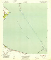
1943 Map of Clifton By The Sea
USGS Topo · Published 1952About this map
Galveston Bay dominates this coastal landscape as it appeared in the early 1940s, showing the early recreational and industrial footprint along the western shore. The waterfront is dotted with small residential developments like El Jardin Del Mar, Surf Oaks, and the resort community of Clifton by the Sea. Inland, the Southern Pacific railroad provides the backbone for transport, connecting the higher ground of Red Bluff to the established grid of San Leon further south.
Find a feature on this map
30 named features on this map. Tap any name to fly to it.
Don’t see what you’re looking for? This feature index may not catch every label — zoom into the map to look around manually.
Map Details
Editions of this 1943 Clifton By The Sea Map
This is the sole edition of this map. No revisions or reprints were ever made.
Other maps of this area

1916 · Morgan Point
USGS Topo · 1:24,000

1916 · Seabrook
USGS Topo · 1:24,000

1916 · La Porte
USGS Topo · 1:24,000

1919 · Morgan Point
USGS Topo · 1:31,680

1920 · Seabrook
USGS Topo · 1:31,680

1920 · La Porte
USGS Topo · 1:31,680

1929 · Dickinson
USGS Topo · 1:24,000

1929 · Texas City
USGS Topo · 1:24,000

1932 · Clifton By The Sea
USGS Topo · 1:31,680

1932 · Dickinson
USGS Topo · 1:31,680