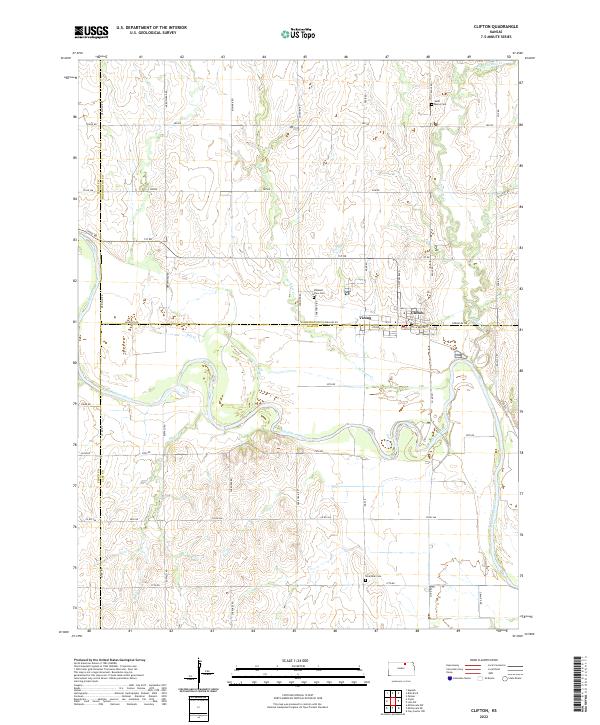
2022 Map of Clifton
USGS Topo · Published 2022About this map
The Republican River winds through the heart of the central Kansas prairie, defining the border where the Clifton and Vining communities meet at the intersection of Washington, Clay, and Cloud counties. This landscape is characterized by its systematic section-line grid, where roads like Meridian Rd and Parallel Rd facilitate movement through a deeply agricultural region. The map reveals a cluster of local history markers, including Saint Marys Cem to the north and Pleasant View Cem near the town center.
Find a feature on this map
54 named features on this map. Tap any name to fly to it.
Don’t see what you’re looking for? This feature index may not catch every label — zoom into the map to look around manually.
Map Details
Editions of this 2022 Clifton Map
This is the sole edition of this map. No revisions or reprints were ever made.
Other maps of this area

1891 · Clay Center
USGS Topo · 1:125,000

1893 · Washington
USGS Topo · 1:125,000

1955 · Manhattan
USGS Topo · 1:250,000

1956 · Manhattan
USGS Topo · 1:250,000

1957 · Manhattan
USGS Topo · 1:250,000

1964 · Clay Center NW
USGS Topo · 1:24,000

1964 · Miltonvale NE
USGS Topo · 1:24,000

1965 · Clifton
USGS Topo · 1:24,000

1965 · Brantford
USGS Topo · 1:24,000
1965 · Miltonvale NW
USGS Topo · 1:24,000