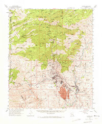
1962 Map of Clifton
USGS Topo · Published 1972About this map
The Morenci Open Pit dominates this industrial landscape, illustrating the massive scale of copper mining in eastern Arizona during the early 1960s. This survey details the complex infrastructure supporting the mine, including an extensive Tailings Pond, a Leaching Pond, and a Smelter near Morenci. The geography reveals a transition from these heavy industrial zones to the rugged wilderness of the Apache National Forest and the San Carlos Indian Reservation. Historic settlement patterns are visible through the proximity of Clifton to the San Francisco River, while the presence of Metcalf (Site) and Oroville (Site) marks the location of former mining communities. Connectivity is provided by the Southern Pacific Railroad and the winding Coronado Trail, which cuts through the high terrain past Mitchell Peak and the Prieto Plateau.
Find a feature on this map
81 named features on this map. Tap any name to fly to it.
Don’t see what you’re looking for? This feature index may not catch every label — zoom into the map to look around manually.
Map Details
Editions of this 1962 Clifton Map
2 editions found

Other maps of this area

1902 · Clifton
USGS Topo · 1:62,500

1913 · Morenci
USGS Topo · 1:125,000

1915 · Morenci
USGS Topo · 1:125,000

1954 · Silver City
USGS Topo · 1:250,000

1954 · Clifton
USGS Topo · 1:250,000

1957 · Clifton
USGS Topo · 1:250,000

1958 · Silver City
USGS Topo · 1:250,000

1958 · Clifton
USGS Topo · 1:250,000

1959 · York Valley
USGS Topo · 1:62,500

1960 · Guthrie
USGS Topo · 1:62,500