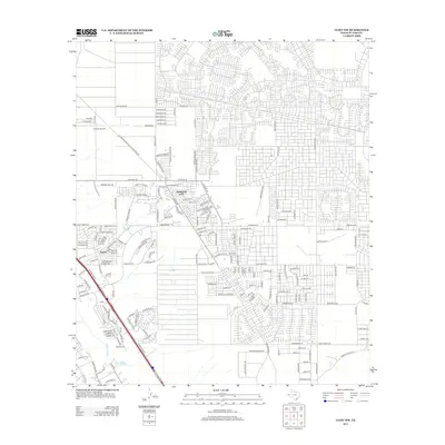
2012 Map of Clint NW
USGS Topo · Published 2012About this map
Horizon City and Sparks anchor this 2012 survey, revealing a landscape of rapid suburban expansion east of El Paso. The area is defined by a dense grid of residential streets encroaching upon the desert, where traditional infrastructure like the Ysleta Lateral and Mesa Drain still trace the historical water management patterns of the Rio Grande valley. To the northwest, Horizon Airport serves as a local landmark, surrounded by a burgeoning network of thoroughfares including Horizon Blvd and Pellicano Dr. A unique industrial feature, the El Paso Natural Gas Maintenance Rd, cuts diagonally across the northern sector, reflecting the importance of energy transit in this border region. This map effectively documents the transition from open Chihuahuan Desert to a modern planned community, marked by family-named streets and new developments like Emerald Creek Dr.
Find a feature on this map
18 named features on this map. Tap any name to fly to it.
Don’t see what you’re looking for? This feature index may not catch every label — zoom into the map to look around manually.
Map Details
Editions of this 2012 Clint NW Map
This is the sole edition of this map. No revisions or reprints were ever made.
Other maps of this area

1896 · El Paso
USGS Topo · 1:125,000

1908 · El Paso
USGS Topo · 1:125,000

1939 · Ysleta
USGS Topo · 1:62,500

1939 · Heuco Tanks
USGS Topo · 1:62,500

1940 · Heuco Tanks
USGS Topo · 1:62,500

1941 · Clint
USGS Topo · 1:62,500

1941 · Ysleta
USGS Topo · 1:62,500

1942 · Fort Bliss
USGS Topo · 1:62,500

1944 · Heuco Tanks
USGS Topo · 1:62,500

1945 · Ysleta
USGS Topo · 1:62,500
Featured Places
- Socorro, TX
- Horizon City, TX
- Agua Dulce Number 5 Colonia, TX
- Spark's Addition Number 2 Colonia, TX
- Spark's Addition Number 3 Colonia, TX