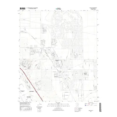
2016 Map of Clint NW
USGS Topo · Published 2016About this map
Horizon City and Socorro anchor this 2016 survey of the Rio Grande valley periphery, showing a landscape defined by residential colonias and essential irrigation infrastructure. The transition from the dense street grids of Sparks and Agua Dulce Colonia to the agricultural systems of the Ysleta Lateral and Mesa Drain reveals the modern growth patterns of El Paso County. The map provides a clear record of smaller communities like McAdoo Acres Colonia and Warren Allen Road Colonia situated among a network of important thoroughfares, including Gateway Blvd W and FM 1281. Tracing the Mesa Spur Drain through these settlements highlights the area's continued reliance on managed water systems amidst rapid suburban expansion.
Find a feature on this map
26 named features on this map. Tap any name to fly to it.
Don’t see what you’re looking for? This feature index may not catch every label — zoom into the map to look around manually.
Map Details
Editions of this 2016 Clint NW Map
This is the sole edition of this map. No revisions or reprints were ever made.
Other maps of this area

1896 · El Paso
USGS Topo · 1:125,000

1908 · El Paso
USGS Topo · 1:125,000

1939 · Ysleta
USGS Topo · 1:62,500

1939 · Heuco Tanks
USGS Topo · 1:62,500

1940 · Heuco Tanks
USGS Topo · 1:62,500

1941 · Clint
USGS Topo · 1:62,500

1941 · Ysleta
USGS Topo · 1:62,500

1942 · Fort Bliss
USGS Topo · 1:62,500

1944 · Heuco Tanks
USGS Topo · 1:62,500

1945 · Ysleta
USGS Topo · 1:62,500
Featured Places
- Socorro, TX
- Horizon City, TX
- Agua Dulce Number 5 Colonia, TX
- Spark's Addition Number 2 Colonia, TX
- Spark's Addition Number 3 Colonia, TX