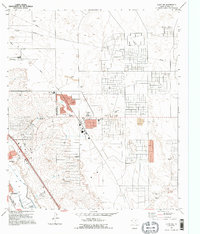
1995 Map of Clint NW
USGS Topo · Published 1995About this map
Horizon City sits at the center of this suburbanizing desert landscape, showing the planned residential layouts and infrastructure typical of El Paso County's expansion in the 1990s. The map documents a transition from agricultural and industrial utility to residential development, with numerous Gravel Pits and extensive pipelines neighboring new schools like Desert Hills Sch and Horizon Heights Sch. To the southwest, the edge of Socorro appears alongside irrigation infrastructure such as the Ysleta Lateral and Daugherty Lateral, which support the lower valley's historical water management system. Large-scale utility features, including the West Texas Airport and multiple feedlots, highlight the varied land use on the Mesa before more dense urbanization occurred.
Find a feature on this map
23 named features on this map. Tap any name to fly to it.
Don’t see what you’re looking for? This feature index may not catch every label — zoom into the map to look around manually.
Map Details
Editions of this 1995 Clint NW Map
This is the sole edition of this map. No revisions or reprints were ever made.
Other maps of this area

1896 · El Paso
USGS Topo · 1:125,000

1908 · El Paso
USGS Topo · 1:125,000

1939 · Ysleta
USGS Topo · 1:62,500

1939 · Heuco Tanks
USGS Topo · 1:62,500

1940 · Heuco Tanks
USGS Topo · 1:62,500

1941 · Clint
USGS Topo · 1:62,500

1941 · Ysleta
USGS Topo · 1:62,500

1942 · Fort Bliss
USGS Topo · 1:62,500

1944 · Heuco Tanks
USGS Topo · 1:62,500

1945 · Ysleta
USGS Topo · 1:62,500
Featured Places
- Socorro, TX
- Horizon City, TX
- Agua Dulce Colonia, TX
- Spark's Addition Colonia, TX
- Spark's Addition Number 2 Colonia, TX