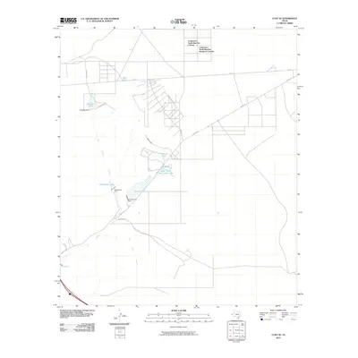
2010 Map of Clint SE
USGS Topo · Published 2010About this map
San Felipe Arroyo winds through this arid West Texas landscape, defining a terrain shaped by water management and ranching developments. The map highlights the growth of residential subdivisions such as Cattleman's North Ranchos Colonia and Cattleman's North Ranchos Number 2 Colonia in the northern portion of the quadrangle. A network of ranch roads and trails, including Iron Horse Trl and Indian Trl, connects various livestock watering points like Harry Tank and Rimrock Tank. The geography of the area is further marked by a series of small dams and reservoirs, such as Rattlesnake Dam holding Rattlesnake Lake, and the larger Indian Cliffs Ranch Main Lake, illustrating the infrastructure required for sustaining life and industry in this desert environment.
Find a feature on this map
20 named features on this map. Tap any name to fly to it.
Don’t see what you’re looking for? This feature index may not catch every label — zoom into the map to look around manually.
Map Details
Editions of this 2010 Clint SE Map
This is the sole edition of this map. No revisions or reprints were ever made.
Other maps of this area

1894 · Fort Hancock
USGS Topo · 1:125,000

1896 · El Paso
USGS Topo · 1:125,000

1896 · Rio Grande
USGS Topo · 1:125,000

1903 · Cerro Alto
USGS Topo · 1:125,000

1908 · El Paso
USGS Topo · 1:125,000

1941 · Clint
USGS Topo · 1:62,500

1941 · Tornillo
USGS Topo · 1:62,500

1942 · Borrego
USGS Topo · 1:62,500

1943 · Fort Hancock
USGS Topo · 1:62,500
1945 · Clint
USGS Topo · 1:62,500
Featured Places
- East Clint Estates Colonia, TX
- Cattleman's North Ranchos Number 2 Colonia, TX
- Cattleman's North Ranchos Colonia, TX
- El Paso County, TX
- United States