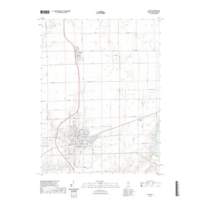
2021 Map of Clinton
USGS Topo · Published 2021About this map
Clinton serves as the focal point of this DeWitt County landscape, shown here at the start of the 2020s. The city is defined by its detailed street grid and significant civic landmarks such as the DeWitt County Building. To the north, the smaller settlement of Wapella sits along the primary north-south corridor, surrounded by an extensive network of rural roads including Toad Hill Rd and Tabor Rd. The area's genealogical significance is evident in the cluster of burial grounds near the city center, including Oak Park Cem, Memorial Park Cem, and Woodlawn Cem.
Find a feature on this map
97 named features on this map. Tap any name to fly to it.
Don’t see what you’re looking for? This feature index may not catch every label — zoom into the map to look around manually.
Map Details
Editions of this 2021 Clinton Map
This is the sole edition of this map. No revisions or reprints were ever made.
Other maps of this area

1949 · Mc Lean
USGS Topo · 1:62,500

1951 · McLean
USGS Topo · 1:62,500

1951 · Le Roy
USGS Topo · 1:62,500

1957 · Kenney
USGS Topo · 1:62,500

1957 · Maroa
USGS Topo · 1:62,500

1958 · Peoria
USGS Topo · 1:250,000

1961 · Peoria
USGS Topo · 1:250,000

1963 · Peoria
USGS Topo · 1:250,000
1979 · Maroa
USGS Topo · 1:24,000

1979 · De Witt
USGS Topo · 1:24,000