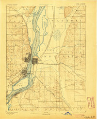
1894 Map of Clinton
USGS Topo · Published 1905About this map
The Mississippi River serves as the dominant geographic and economic artery of this region, dividing the riverfront communities of Iowa and Illinois. The street grids of Clinton and Lyons are clearly defined along the western bank, while Fulton sits opposite, linked by a complex network of iron and steam. Large river features such as Big Beaver Island and Little Rock Island redirect the main channel, illustrating the river's braided nature before modern lock and dam systems.
Find a feature on this map
43 named features on this map. Tap any name to fly to it.
Don’t see what you’re looking for? This feature index may not catch every label — zoom into the map to look around manually.
Map Details
Editions of this 1894 Clinton Map
3 editions found
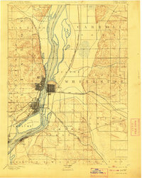
Other maps of this area

1891 · Clinton
USGS Topo · 1:62,500

1892 · Goose Lake
USGS Topo · 1:62,500

1892 · Savanna
USGS Topo · 1:62,500

1892 · Leclaire
USGS Topo · 1:62,500

1893 · Leclaire
USGS Topo · 1:62,500

1894 · Goose Lake
USGS Topo · 1:62,500

1894 · Clinton
USGS Topo · 1:62,500

1899 · Clinton
USGS Topo · 1:125,000

1932 · Prophetstown
USGS Topo · 1:48,000

1934 · Morrison
USGS Topo · 1:48,000