
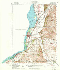
1952 Map of Clinton
USGS Topo · Published 1953About this map
The Upper Mississippi River Wildlife and Fish Refuge dominates the western edge of this mid-century survey, illustrating the complex hydrology of the river before and after the construction of Lock and Dam No 13. The landscape is a network of backwaters like Cattail Slough and Old River Lake, set against a dense infrastructure of the Chicago Milwaukee St Paul and Pacific and other major rail lines. On the Illinois side, the river towns of Fulton, Thomson, and Albany serve as anchors for a rural interior dotted with local institutions. Genealogists will find a wealth of specific landmarks, from York Ch to numerous country schoolhouses like Ebner Sch and Otter Bluff Sch. The transition of the land is noted at Green Valley Sch (Abandoned), while the enduring presence of local history is marked by sites such as Cottonwood Cem.
Find a feature on this map
47 named features on this map. Tap any name to fly to it.
Don’t see what you’re looking for? This feature index may not catch every label — zoom into the map to look around manually.
Map Details
Editions of this 1952 Clinton Map
2 editions found
Other maps of this area

1891 · Clinton
USGS Topo · 1:62,500

1892 · Goose Lake
USGS Topo · 1:62,500

1892 · Savanna
USGS Topo · 1:62,500

1892 · Leclaire
USGS Topo · 1:62,500

1893 · Leclaire
USGS Topo · 1:62,500

1894 · Goose Lake
USGS Topo · 1:62,500

1894 · Clinton
USGS Topo · 1:62,500

1899 · Clinton
USGS Topo · 1:125,000

1932 · Prophetstown
USGS Topo · 1:48,000

1934 · Morrison
USGS Topo · 1:48,000