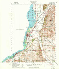
1952 Map of Clinton
USGS Topo · Published 1971About this map
The Mississippi River corridor dominates this 1950s survey, illustrating a landscape defined by the Upper Mississippi River Wildlife and Fish Refuge and large-scale water management. Engineering works like Lock and Dam No 13 and the Cattail Slough levee system reveal how the region’s hydrology was reshaped for navigation and flood control. Along the eastern bluffs and floodplains, a dense network of one-room schoolhouses, such as Stone St Sch and Lockhart Sch, serves as a marker of the mid-century rural education system before widespread consolidation.
Find a feature on this map
58 named features on this map. Tap any name to fly to it.
Don’t see what you’re looking for? This feature index may not catch every label — zoom into the map to look around manually.
Map Details
Editions of this 1952 Clinton Map
2 editions found

Other maps of this area

1891 · Clinton
USGS Topo · 1:62,500

1892 · Goose Lake
USGS Topo · 1:62,500

1892 · Savanna
USGS Topo · 1:62,500

1892 · Leclaire
USGS Topo · 1:62,500

1893 · Leclaire
USGS Topo · 1:62,500

1894 · Goose Lake
USGS Topo · 1:62,500

1894 · Clinton
USGS Topo · 1:62,500

1899 · Clinton
USGS Topo · 1:125,000

1932 · Prophetstown
USGS Topo · 1:48,000

1934 · Morrison
USGS Topo · 1:48,000