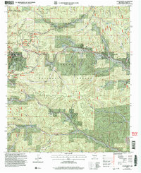
2004 Map of Cloudcroft
USGS Topo · Published 2006About this map
The village of Cloudcroft serves as a high-altitude hub in the Sacramento Mountains, surrounded by the protected lands of the Lincoln National Forest. By the early 2000s, the landscape reflects a well-established recreational economy, anchored by the Ski Cloudcroft Ski Area, the Apache Recreation Area, and the Silver Snowplay Area. Notable for its combination of scientific and natural resources, the area features the Wofford Lookout Tower and a nearby Observatory, while cultural sites like the Silver Amphitheatre and Bass Cem provide a look into the community's local history. The complex network of canyons, including James Canyon and Cox Canyon, dictates the local geography and road placement. Smaller settlements and named sites such as Wimsatt and Chippeway Park dot the terrain, illustrating the gradual expansion of development within the forest boundaries during this era.
Find a feature on this map
54 named features on this map. Tap any name to fly to it.
Don’t see what you’re looking for? This feature index may not catch every label — zoom into the map to look around manually.
Map Details
Editions of this 2004 Cloudcroft Map
This is the sole edition of this map. No revisions or reprints were ever made.
Other maps of this area

1950 · Alamogordo
USGS Topo · 1:62,500

1950 · Mescalero
USGS Topo · 1:62,500

1952 · Cloudcroft
USGS Topo · 1:62,500

1954 · Carlsbad
USGS Topo · 1:250,000

1955 · Roswell
USGS Topo · 1:250,000

1958 · Carlsbad
USGS Topo · 1:250,000

1958 · Roswell
USGS Topo · 1:250,000

1962 · Roswell
USGS Topo · 1:250,000

1963 · Firman Canyon
USGS Topo · 1:24,000
1963 · Elk-Silver
USGS Topo · 1:24,000