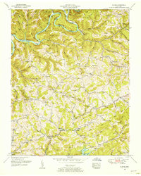
1952 Map of Clouds
USGS Topo · Published 1954About this map
The Powell River snakes through northern Claiborne County, its deep bends and rising waters forming the upper reaches of Norris Lake in the early 1950s. The landscape is defined by the corrugated ridges of Lonesome Valley and Wallen Ridge, where small upland communities like Clouds and Lily Grove persist along the winding hollows. This era shows a rural network still heavily reliant on local institutions, with numerous country schools and churches dotting the topography, including the Sandlick School and Watson Chapel.
Find a feature on this map
119 named features on this map. Tap any name to fly to it.
Don’t see what you’re looking for? This feature index may not catch every label — zoom into the map to look around manually.
Map Details
Editions of this 1952 Clouds Map
4 editions found
Other maps of this area

1886 · Cumberland Gap
USGS Topo · 1:125,000

1888 · Cumberland Gap
USGS Topo · 1:125,000

1891 · Cumberland Gap
USGS Topo · 1:125,000

1897 · Maynardville
USGS Topo · 1:125,000

1900 · Maynardville
USGS Topo · 1:125,000

1903 · Middlesboro
USGS Topo · 1:48,000

1927 · Middlesboro
USGS Topo · 1:62,500

1930 · Middlesboro
USGS Topo · 1:62,500

1935 · Mingo Mountains
USGS Topo · 1:24,000

1935 · Cumberland Gap
USGS Topo · 1:24,000