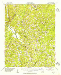
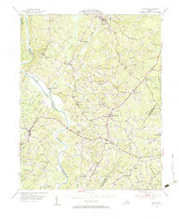
1954 Map of Clover
USGS Topo · Published 1956About this map
The Roanoke River snakes through the center of this Southside Virginia landscape, forming a natural boundary between Charlotte and Halifax counties. At the time of this mid-century field check, the Southern Railway remains a primary corridor for transport, connecting established communities like Drakes Branch, Mossingford, and Randolph. The map documents a rural infrastructure heavily reliant on small local institutions, marked by numerous named country churches such as Hebron Ch, Bethel Ch, and New Hope Ch, as well as schools like Staunton River Sch and Salem Sch.
Find a feature on this map
71 named features on this map. Tap any name to fly to it.
Don’t see what you’re looking for? This feature index may not catch every label — zoom into the map to look around manually.
Map Details
Editions of this 1954 Clover Map
2 editions found
Other maps of this area

1891 · Farmville
USGS Topo · 1:125,000

1892 · Appomattox
USGS Topo · 1:125,000

1893 · Farmville
USGS Topo · 1:125,000

1941 · Clarksville
USGS Topo · 1:48,000

1943 · Clarksville
USGS Topo · 1:62,500

1947 · Roanoke
USGS Topo · 1:250,000

1953 · South Boston
USGS Topo · 1:62,500

1953 · Greensboro
USGS Topo · 1:250,000

1954 · Greensboro
USGS Topo · 1:250,000
1954 · Clover
USGS Topo · 1:62,500