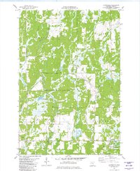
1981 Map of Cloverdale
USGS Topo · Published 1982About this map
Cloverdale serves as the primary settlement center in this Pine County landscape, where the Cloverdale Townhall and nearby Clover Cem mark the community's local history. Much of the terrain is defined by conservation and water management, with the Pine County State Game Refuge and Sandstone State Game Refuge covering significant portions of the northern and central sections. This 1981 survey reveals a landscape interlaced with numerous small waterways including Partridge Creek, Hay Creek, and Zimbrick Brook, which feed into Wallace Lake and various low-lying wetlands. The southern edge of the map transitions into the recreational space of St Croix State Park, featuring a Campground and showing the area's development for public use in the early 1980s. Throughout the quadrangle, several Gravel Pits indicate local resource extraction amidst the protected game lands and township boundaries of Arlone and Clover.
Find a feature on this map
21 named features on this map. Tap any name to fly to it.
Don’t see what you’re looking for? This feature index may not catch every label — zoom into the map to look around manually.
Map Details
Editions of this 1981 Cloverdale Map
This is the sole edition of this map. No revisions or reprints were ever made.
Other maps of this area

1950 · Grantsburg
USGS Topo · 1:48,000

1953 · Duluth
USGS Topo · 1:250,000

1953 · Stillwater
USGS Topo · 1:250,000

1955 · Stillwater
USGS Topo · 1:250,000

1958 · Stillwater
USGS Topo · 1:250,000

1958 · Duluth
USGS Topo · 1:250,000

1961 · Sandstone
USGS Topo · 1:62,500

1961 · Pine City
USGS Topo · 1:62,500

1962 · Cloverdale
USGS Topo · 1:62,500

1962 · Grantsburg
USGS Topo · 1:62,500