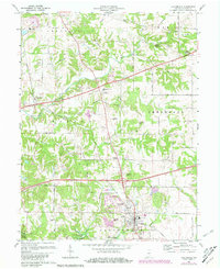
1970 Map of Cloverdale
USGS Topo · Published 1981About this map
Putnamville and Cloverdale serve as the primary hubs in this central Indiana landscape, captured at a time when the region's agricultural roots intersected with mid-century infrastructure. The Louisville and Nashville railroad and the Old RR Grade trace the historical transportation corridors, while the Putnam County Airport and a prominent Drive-in Theater west of South Putnam Sch signal the era's modern shifts. The terrain is marked by distinctive elevations like Devils Backbone and Hughes Hill, which overlook the winding paths of Deer Creek and Upper Limestone Creek. For local historians, the map preserves the exact locations of several small burial grounds and spiritual centers, including Old Bethel Cem and Beer Creek Ch. The southern edge is defined by the recreation and water management area of Cagles Mill Lake and the Owen-Putnam State Forest, illustrating the balance between managed wilderness and rural development.
Find a feature on this map
52 named features on this map. Tap any name to fly to it.
Don’t see what you’re looking for? This feature index may not catch every label — zoom into the map to look around manually.
Map Details
Editions of this 1970 Cloverdale Map
3 editions found
Other maps of this area

1949 · Quincy
USGS Topo · 1:24,000

1951 · Clinton Falls
USGS Topo · 1:24,000

1952 · Reelsville
USGS Topo · 1:24,000

1953 · Indianapolis
USGS Topo · 1:250,000

1956 · Indianapolis
USGS Topo · 1:250,000

1956 · Cloverdale
USGS Topo · 1:24,000

1956 · Cataract
USGS Topo · 1:24,000

1956 · Eminence
USGS Topo · 1:24,000

1957 · Indianapolis
USGS Topo · 1:250,000
1957 · Poland
USGS Topo · 1:24,000