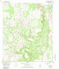
1966 Map of Club Hollow
USGS Topo · Published 1984About this map
North Prong Pecan Bayou and Rough Creek define the drainage of this Callahan County landscape as it was documented in the mid-1960s. The terrain is a network of ridges and hollows, most notably Club Hollow and the valley of Mexia Creek in the eastern portion of the quadrangle. Petroleum development is evident throughout the area, with numerous Oil Wells and pipelines scattered across the ranch land, alongside several Gravel Pits.
Find a feature on this map
12 named features on this map. Tap any name to fly to it.
Don’t see what you’re looking for? This feature index may not catch every label — zoom into the map to look around manually.
Map Details
Editions of this 1966 Club Hollow Map
Other maps of this area

1890 · Abilene
USGS Topo · 1:125,000

1892 · Abilene
USGS Topo · 1:125,000

1931 · Baird
USGS Topo · 1:125,000

1932 · Baird
USGS Topo · 1:125,000

1954 · Abilene
USGS Topo · 1:250,000

1957 · Kirby Lake
USGS Topo · 1:62,500

1958 · Abilene
USGS Topo · 1:250,000
1966 · Baird
USGS Topo · 1:24,000

1966 · Admiral
USGS Topo · 1:24,000
1966 · Cub Hollow
USGS Topo · 1:24,000