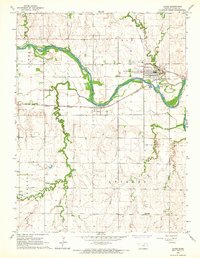
1965 Map of Clyde
USGS Topo · Published 1966About this map
The Republican River carves a winding path through the northern plains of Cloud County, serving as the central geographic feature for the established settlements of Clyde and Ames. This mid-century survey illustrates a landscape defined by the intersection of river transport and rail infrastructure, with the Chicago Rock Island and Pacific and Missouri Pacific lines converging near the town centers. The distribution of small rural hubs like St Joseph and family-named landmarks such as Morgan Chapel suggests a stable agricultural community rooted in the early 20th century.
Find a feature on this map
25 named features on this map. Tap any name to fly to it.
Don’t see what you’re looking for? This feature index may not catch every label — zoom into the map to look around manually.
Map Details
Editions of this 1965 Clyde Map
This is the sole edition of this map. No revisions or reprints were ever made.
Other maps of this area
1891 · Clay Center
USGS Topo · 1:125,000
1892 · Concordia
USGS Topo · 1:125,000
1892 · Minneapolis
USGS Topo · 1:125,000
1893 · Washington
USGS Topo · 1:125,000
1955 · Manhattan
USGS Topo · 1:250,000
1956 · Manhattan
USGS Topo · 1:250,000
1957 · Manhattan
USGS Topo · 1:250,000
1964 · Miltonvale NE
USGS Topo · 1:24,000
1965 · Clifton
USGS Topo · 1:24,000
1965 · Aurora
USGS Topo · 1:24,000