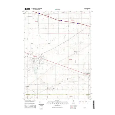
2016 Map of Clyde
USGS Topo · Published 2016About this map
The city of Clyde and the western edge of Bellevue anchor this 2016 survey of the north-central Ohio landscape. This region, split by the Sandusky Co and Seneca Co boundary, exhibits a dense network of country roads and scattered rural settlements such as Wales Corners, Mount Carmel, Colby, and Galetown. The local topography is defined by the northward flow of numerous waterways, including Raccoon Cr, Pickerel Cr, and Strong Cr, which drain toward Lake Erie.
Find a feature on this map
74 named features on this map. Tap any name to fly to it.
Don’t see what you’re looking for? This feature index may not catch every label — zoom into the map to look around manually.
Map Details
Editions of this 2016 Clyde Map
This is the sole edition of this map. No revisions or reprints were ever made.
Other maps of this area

1901 · Bellevue
USGS Topo · 1:62,500

1901 · Fremont
USGS Topo · 1:62,500

1903 · Bellevue
USGS Topo · 1:62,500

1903 · Fremont
USGS Topo · 1:62,500

1906 · Tiffin
USGS Topo · 1:62,500

1915 · Siam
USGS Topo · 1:62,500

1956 · Toledo
USGS Topo · 1:250,000

1957 · Vickery
USGS Topo · 1:24,000
1957 · Wightmans Grove
USGS Topo · 1:24,000
1958 · Fremont East
USGS Topo · 1:24,000