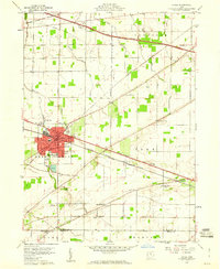
1959 Map of Clyde
USGS Topo · Published 1960About this map
The railroad junction at Clyde serves as a central hub in this late 1950s landscape, where the New York Central Railroad and the New York Central and St Louis Railroad intersect. This transit-driven geometry is mirrored in the surrounding townships of Riley, Green Creek, and York, where the modern Ohio Toll Road Turnpike and the General Mc Pherson Highway cut through a grid of rural farmland. Local life is anchored by family and community landmarks, from the McPherson Cemetery in town to rural worship sites like Mt Carmel Ch and Butternut Ridge Chapel. Along the southern border, Butternut Ridge provides a distinct geographical break near the small settlement of Colby. The inclusion of civic infrastructure like City Hall, a South Main Sch, and several local cemeteries provides a clear view of mid-century settlement patterns in Sandusky and Seneca Counties.
Find a feature on this map
33 named features on this map. Tap any name to fly to it.
Don’t see what you’re looking for? This feature index may not catch every label — zoom into the map to look around manually.
Map Details
Editions of this 1959 Clyde Map
This is the sole edition of this map. No revisions or reprints were ever made.
Other maps of this area

1901 · Bellevue
USGS Topo · 1:62,500

1901 · Fremont
USGS Topo · 1:62,500

1903 · Bellevue
USGS Topo · 1:62,500

1903 · Fremont
USGS Topo · 1:62,500

1906 · Tiffin
USGS Topo · 1:62,500

1915 · Siam
USGS Topo · 1:62,500

1956 · Toledo
USGS Topo · 1:250,000

1957 · Vickery
USGS Topo · 1:24,000
1957 · Wightmans Grove
USGS Topo · 1:24,000
1958 · Fremont East
USGS Topo · 1:24,000