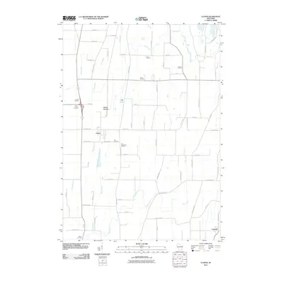
2010 Map of Clyman
USGS Topo · Published 2010About this map
Clyman Junction and the nearby village of Clyman anchor this Dodge County landscape, illustrating a classic Wisconsin agricultural and rail corridor. The map reveals a dense network of local history through its numerous burial grounds, including the Holy Assumption Cemetery and Zion Cemetery, which suggest the ethnic and religious fabric of the early settlers. Water drainage is a defining characteristic of the terrain, with Dead Creek, Casper Creek, and Silver Creek winding through the gridded road system. Notable family-named roads like Schoechert Rd and Gubin Rd further emphasize the deep-rooted genealogical history of the area. In the southeast, the community of Lebanon marks the edge of the survey, where Baker Creek flows toward the Rock River watershed.
Find a feature on this map
64 named features on this map. Tap any name to fly to it.
Don’t see what you’re looking for? This feature index may not catch every label — zoom into the map to look around manually.
Map Details
Editions of this 2010 Clyman Map
This is the sole edition of this map. No revisions or reprints were ever made.
Other maps of this area

1891 · Waterloo
USGS Topo · 1:62,500

1892 · Watertown
USGS Topo · 1:62,500

1894 · Waterloo
USGS Topo · 1:62,500

1894 · Watertown
USGS Topo · 1:62,500

1910 · Waterloo
USGS Topo · 1:62,500

1955 · Beaver Dam
USGS Topo · 1:62,500

1955 · Horicon
USGS Topo · 1:62,500

1957 · Madison
USGS Topo · 1:250,000
1959 · Richwood
USGS Topo · 1:24,000

1959 · Ixonia
USGS Topo · 1:24,000