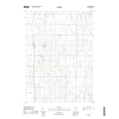
2018 Map of Clyman
USGS Topo · Published 2018About this map
The agricultural landscape of Dodge County is defined by a dense network of country roads and small rural centers. Clyman sits as a primary hub, while Clyman Junction to the north reflects the historical intersection of rail lines and early transport routes. The region is notable for its numerous well-preserved burial grounds, which serve as vital markers for local genealogy. From the Holy Assumption Cem and Zion Cem in the central district to the Mengel Cem on the outskirts of town, these sites preserve the names of the area's early settlers.
Find a feature on this map
87 named features on this map. Tap any name to fly to it.
Don’t see what you’re looking for? This feature index may not catch every label — zoom into the map to look around manually.
Map Details
Editions of this 2018 Clyman Map
This is the sole edition of this map. No revisions or reprints were ever made.
Other maps of this area

1891 · Waterloo
USGS Topo · 1:62,500

1892 · Watertown
USGS Topo · 1:62,500

1894 · Waterloo
USGS Topo · 1:62,500

1894 · Watertown
USGS Topo · 1:62,500

1910 · Waterloo
USGS Topo · 1:62,500

1955 · Beaver Dam
USGS Topo · 1:62,500

1955 · Horicon
USGS Topo · 1:62,500

1957 · Madison
USGS Topo · 1:250,000
1959 · Richwood
USGS Topo · 1:24,000

1959 · Ixonia
USGS Topo · 1:24,000