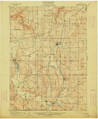
1905 Map of Clymer
USGS Topo · Published 1913About this map
The agricultural valleys of southwest Chautauqua County are defined here by a dense network of hamlets and rural crossroads before the automotive era fully reshaped the region. Small communities such as North Clymer, Sherman, and Clymer serve as hubs along the Pennsylvania and New York Western R R, which cuts through the center of the landscape. To the west, the village of Findley Lake sits at the edge of its namesake water body, a prominent landmark in the township of Mina.
Find a feature on this map
53 named features on this map. Tap any name to fly to it.
Don’t see what you’re looking for? This feature index may not catch every label — zoom into the map to look around manually.
Map Details
Editions of this 1905 Clymer Map
4 editions found
Other maps of this area

1899 · Westfield
USGS Topo · 1:62,500

1900 · Dunkirk
USGS Topo · 1:62,500

1904 · Chautaqua
USGS Topo · 1:62,500

1905 · Clymer
USGS Topo · 1:62,500

1913 · North East
USGS Topo · 1:62,500

1915 · North East
USGS Topo · 1:62,500

1926 · Youngsville
USGS Topo · 1:62,500

1929 · Corry
USGS Topo · 1:48,000

1929 · Youngsville
USGS Topo · 1:62,500

1929 · Union City
USGS Topo · 1:62,500