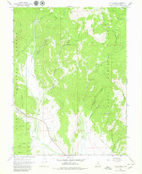
1967 Map of Co-Op Creek
USGS Topo · Published 1980About this map
The Treaty Indian Boundary cuts across this high-elevation landscape within the Uinta National Forest, marking a significant historical line in Wasatch County. The intricate water management system of the era is visible through the Currant Creek Feeder Canal and a Siphon near Mill B Flat. These features, alongside numerous springs like Bull Spring, supported the region's early ranching and resource activities. Remote infrastructure is anchored by the Hub Guard Station and scattered Corral sites, while the presence of a Quarry near Hobble Creek Trail indicates localized industrial efforts. The topography is defined by deep drainages such as Shingle Mill Hollow and Bjorkman Hollow, which feed into the southern-flowing Strawberry River and Co-op Creek.
Find a feature on this map
39 named features on this map. Tap any name to fly to it.
Don’t see what you’re looking for? This feature index may not catch every label — zoom into the map to look around manually.
Map Details
Editions of this 1967 Co-Op Creek Map
2 editions found
Other maps of this area

1885 · Salt Lake
USGS Topo · 1:250,000

1907 · Strawberry Valley
USGS Topo · 1:125,000

1909 · Strawberry Valley
USGS Topo · 1:125,000

1954 · Salt Lake City
USGS Topo · 1:250,000

1958 · Salt Lake City
USGS Topo · 1:250,000

1960 · Salt Lake City
USGS Topo · 1:250,000

1966 · Strawberry Reservoir NW
USGS Topo · 1:24,000
1966 · Strawberry Reservoir NE
USGS Topo · 1:24,000

1967 · Two Tom Hill
USGS Topo · 1:24,000
1967 · Center Creek
USGS Topo · 1:24,000