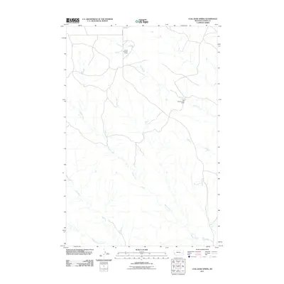
2011 Map of Coal Bank Spring
USGS Topo · Published 2011About this map
Harris Creek and Muster Creek define the drainage patterns of this sparsely developed Custer County landscape during the early 21st century. The map reveals an environment where water management is critical for land use, evidenced by the presence of Kountz Number 2 Dam and Cap Rock Number 4 Dam. These structures, along with Coal Bank Spring, highlight the importance of specific water sources in this part of Montana. Transportation is limited to a few named thoroughfares such as Reed Rd and Caprock Rd, which provide access to the drainages of Sand Creek and its tributary, West Fork Sand Creek. This survey captures a moment in time where the terrain remains largely defined by its natural watercourses and small-scale infrastructure rather than urban expansion.
Find a feature on this map
9 named features on this map. Tap any name to fly to it.
Don’t see what you’re looking for? This feature index may not catch every label — zoom into the map to look around manually.
Map Details
Editions of this 2011 Coal Bank Spring Map
This is the sole edition of this map. No revisions or reprints were ever made.
Other maps of this area

1953 · Miles City
USGS Topo · 1:250,000

1957 · Miles City
USGS Topo · 1:250,000

1958 · Miles City
USGS Topo · 1:250,000

1965 · Twin Buttes School
USGS Topo · 1:24,000

1965 · Morehouse Creek
USGS Topo · 1:24,000

1969 · Horse Creek Hill
USGS Topo · 1:24,000

1969 · Noble Reservoir
USGS Topo · 1:24,000
1969 · Deadman Creek
USGS Topo · 1:24,000
1969 · Coal Bank Spring
USGS Topo · 1:24,000

1969 · Kinsey
USGS Topo · 1:24,000