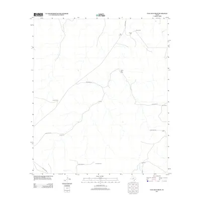
2012 Map of Coal Kiln Draw
USGS Topo · Published 2012About this map
The expansive ranch lands of Schleicher County are the defining feature of this high-plateau landscape, characterized by intermittent watercourses like Coal Kiln Draw and Epps Cr. Settlement is defined by large, family-named operations, including the Hardgrave Ranch, U X Ranch, and the C Valliant Ranch. This area of the Edwards Plateau maintains a sparse, agrarian character where private roads provide the primary access to remote holdings. Genealogists and local historians can trace legacy landownership through labels such as the Morales Ranch and the Morales Cem, the latter serving as a localized point of historical significance amidst the open range. The drainage patterns of W Copperas Cr in the southeast corner illustrate the complex hydrology of this West Texas region, where terrain and cattle ranching have long dictated the pace of development.
Find a feature on this map
21 named features on this map. Tap any name to fly to it.
Don’t see what you’re looking for? This feature index may not catch every label — zoom into the map to look around manually.
Map Details
Editions of this 2012 Coal Kiln Draw Map
This is the sole edition of this map. No revisions or reprints were ever made.
Other maps of this area

1893 · Fort McKavett
USGS Topo · 1:125,000

1954 · Sonora
USGS Topo · 1:250,000

1958 · Sonora
USGS Topo · 1:250,000

1963 · Buffalo Well
USGS Topo · 1:24,000

1963 · McKegan Draw
USGS Topo · 1:24,000

1963 · Buffalo Well SE
USGS Topo · 1:24,000

1963 · Adams SE
USGS Topo · 1:24,000
1963 · Brokeleg Mountain
USGS Topo · 1:24,000
1963 · Coal Kiln Draw
USGS Topo · 1:24,000

1963 · McKegan Draw NE
USGS Topo · 1:24,000