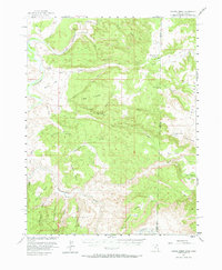
1954 Map of Coates Creek
USGS Topo · Published 1973About this map
The Colorado River and Dolores River carve through a landscape of high plateaus and complex canyon systems along the border of Grand County, Utah, and Mesa County, Colorado. In the mid-1950s, this area was characterized by its isolation and specialized land use, evidenced by the Picture Gallery Ranch and the isolated Landing Strip on Steamboat Mesa. The intricate topography is defined by massive formations like Seven Mile Mesa, Buckhorn Mesa, and the distinct geometric landmarks of Big Triangle and Little Triangle. Along the riverbanks, features such as Utah Bottoms and Cane Spring mark rare points of accessibility in the steep terrain. Historic movement through the region is traced by the Ryan Trail, which navigates the draws and canyons like Ryan Creek and Granite Creek.
Find a feature on this map
51 named features on this map. Tap any name to fly to it.
Don’t see what you’re looking for? This feature index may not catch every label — zoom into the map to look around manually.
Map Details
Editions of this 1954 Coates Creek Map
3 editions found

Other maps of this area

1885 · East Tavaputs
USGS Topo · 1:250,000

1885 · La Sal
USGS Topo · 1:250,000

1949 · Gateway
USGS Topo · 1:24,000

1952 · Gateway
USGS Topo · 1:24,000

1954 · Westwater 4 SW
USGS Topo · 1:24,000

1954 · Mt. Waas 4 NE
USGS Topo · 1:24,000

1954 · Mt. Waas 4 NW
USGS Topo · 1:24,000

1954 · Mt. Waas 3 NE
USGS Topo · 1:24,000

1954 · Mt. Waas 1 SW
USGS Topo · 1:24,000

1954 · Mt. Waas 1 NE
USGS Topo · 1:24,000