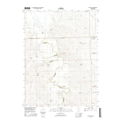
2015 Map of Coatsville
USGS Topo · Published 2015About this map
Coal City and Coatsville anchor this northern Missouri landscape, situated where the state border meets the jagged path of the Chariton River. This terrain is defined by the winding river valley and its numerous tributaries, including Turkey Cr and Spring Cr, which have carved the upland plateaus into a network of ridges and hollows. The area maintains a high concentration of burial grounds, providing a significant genealogical resource for those tracing local lineages through sites such as Hilltown Cemetery, Saint John Cemetery, and Hargrave Cemetery.
Find a feature on this map
72 named features on this map. Tap any name to fly to it.
Don’t see what you’re looking for? This feature index may not catch every label — zoom into the map to look around manually.
Map Details
Editions of this 2015 Coatsville Map
This is the sole edition of this map. No revisions or reprints were ever made.
Other maps of this area

1911 · Queen City
USGS Topo · 1:62,500

1912 · Green City
USGS Topo · 1:62,500

1913 · Queen City
USGS Topo · 1:62,500

1914 · Green City
USGS Topo · 1:62,500

1939 · Centerville
USGS Topo · 1:62,500

1941 · Centerville
USGS Topo · 1:62,500

1954 · Centerville
USGS Topo · 1:250,000

1957 · Centerville
USGS Topo · 1:250,000

1958 · Centerville
USGS Topo · 1:250,000
1974 · Green City NE
USGS Topo · 1:24,000