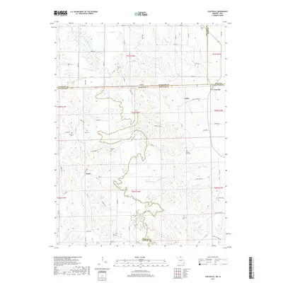
2017 Map of Coatsville
USGS Topo · Published 2017About this map
Coatsville sits near the intersection of state lines and county boundaries, a focal point in a landscape defined by the winding course of the Chariton River. This area along the Missouri-Iowa border shows a dispersed settlement pattern characterized by numerous family and community burial grounds, such as Hilltown Cem, Pleasant Grove Cem, and Shumate Cem, which offer significant value for genealogical research. The terrain is divided by a network of named creeks, including Turkey Cr and Spring Cr, while the modern Prairie Recreation Lake provides a centralized water feature amidst the timbered draws.
Find a feature on this map
50 named features on this map. Tap any name to fly to it.
Don’t see what you’re looking for? This feature index may not catch every label — zoom into the map to look around manually.
Map Details
Editions of this 2017 Coatsville Map
This is the sole edition of this map. No revisions or reprints were ever made.
Other maps of this area

1911 · Queen City
USGS Topo · 1:62,500

1912 · Green City
USGS Topo · 1:62,500

1913 · Queen City
USGS Topo · 1:62,500

1914 · Green City
USGS Topo · 1:62,500

1939 · Centerville
USGS Topo · 1:62,500

1941 · Centerville
USGS Topo · 1:62,500

1954 · Centerville
USGS Topo · 1:250,000

1957 · Centerville
USGS Topo · 1:250,000

1958 · Centerville
USGS Topo · 1:250,000
1974 · Green City NE
USGS Topo · 1:24,000