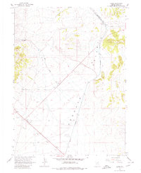
1967 Map of Cobre
USGS Topo · Published 1980About this map
Cobre stands at a historic junction in the high desert of Elko County, marking the point where the Nevada Northern railroad met the main line of the Southern Pacific. This 1967 survey captures the stark layout of the Goshute Valley, where transportation and ranching dictated the thin footprint of human activity. To the west, Squaw Creek Ranch is situated near the seasonal drainage of East Squaw Creek, while the small settlement of Oasis serves as a lonely outpost along the desert road. The landscape is etched with a network of Jeep Trails and dotted with several Gravel Pits, reflecting the area's industrial utility. Two Landing Strips emphasize the necessity of aerial access in this expansive basin, which remains defined by its isolation and its role as a critical rail-transfer hub between the copper mines to the south and the transcontinental line.
Find a feature on this map
12 named features on this map. Tap any name to fly to it.
Don’t see what you’re looking for? This feature index may not catch every label — zoom into the map to look around manually.
Map Details
Editions of this 1967 Cobre Map
3 editions found

Other maps of this area

1955 · Wells
USGS Topo · 1:250,000

1955 · Elko
USGS Topo · 1:250,000

1958 · Wells
USGS Topo · 1:250,000

1958 · Elko
USGS Topo · 1:250,000

1961 · Wells
USGS Topo · 1:250,000

1962 · Elko
USGS Topo · 1:250,000

1965 · Elko
USGS Topo · 1:250,000

1967 · Valley Pass
USGS Topo · 1:24,000

1967 · Loray
USGS Topo · 1:24,000

1967 · Cobre SE
USGS Topo · 1:24,000