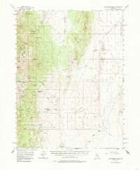
1956 Map of Cockalorum Wash
USGS Topo · Published 1985About this map
The Pancake Range dominates this mid-century Nevada interior, where water sources dictated the patterns of remote ranching and travel. Isolated outposts like Indian Spring Ranch, Willow Creek Ranch, and Snowball Ranch are tied to the dependable drainage of the Cockalorum Wash and Little Smoky Valley. The landscape is a complex network of springs and pipelines, including the Davis Pipeline and Kinkead Spring, which supported livestock and small-scale operations in this arid environment. Geologically, the area is defined by sharp elevation changes and the prominent Big Fault running along the eastern valley floor. The map captures a moment when jeep trails and unimproved roads were the primary lifelines connecting family-named landmarks like Bills Peak and Bisoni Ridge to the broader basins of Eureka and Nye counties.
Find a feature on this map
48 named features on this map. Tap any name to fly to it.
Don’t see what you’re looking for? This feature index may not catch every label — zoom into the map to look around manually.
Map Details
Editions of this 1956 Cockalorum Wash Map
3 editions found
Other maps of this area

1926 · Roberts Mountains
USGS Topo · 1:250,000

1929 · Roberts Mountains
USGS Topo · 1:250,000

1953 · Pinto Summit
USGS Topo · 1:62,500

1955 · Millett
USGS Topo · 1:250,000

1956 · Bellevue Peak
USGS Topo · 1:62,500

1956 · Cockalorum Wash
USGS Topo · 1:62,500

1956 · Horse Heaven Mtn
USGS Topo · 1:62,500

1956 · Antelope Peak
USGS Topo · 1:62,500

1956 · Lund
USGS Topo · 1:250,000

1956 · Ely
USGS Topo · 1:250,000