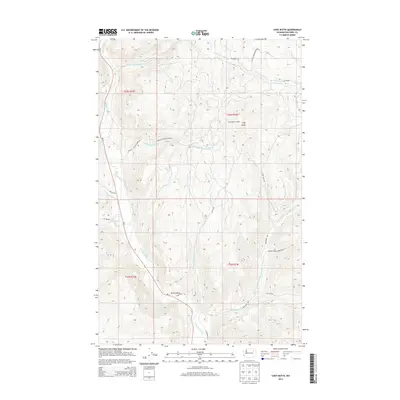
2014 Map of Cody Butte
USGS Topo · Published 2014About this map
The Sanpoil River valley dominates this portion of the Colville Indian Reservation, winding through a landscape defined by significant elevation changes and numerous seasonal drainages. The settlement of Devils Elbow is situated near a sharp bend in the river, where several Bureau of Indian Affairs routes, such as BIA 76 Rd and BIA 1045 Rd, converge. This infrastructure highlights the remote yet managed nature of the timber and ranching lands within the reservation boundaries.
Find a feature on this map
26 named features on this map. Tap any name to fly to it.
Don’t see what you’re looking for? This feature index may not catch every label — zoom into the map to look around manually.
Map Details
Editions of this 2014 Cody Butte Map
This is the sole edition of this map. No revisions or reprints were ever made.
Other maps of this area

1950 · Nespelem
USGS Topo · 1:62,500

1952 · Keller
USGS Topo · 1:62,500

1953 · Seventeenmile Mtn.
USGS Topo · 1:62,500

1953 · Bald Knob
USGS Topo · 1:62,500

1954 · Okanogan
USGS Topo · 1:250,000

1958 · Okanogan
USGS Topo · 1:250,000

1984 · Nespelem
USGS Topo · 1:100,000

1986 · Central Peak
USGS Topo · 1:24,000
1989 · Nespelem NE
USGS Topo · 1:24,000
1989 · Seventeenmile Mountain
USGS Topo · 1:24,000