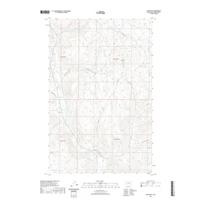
2020 Map of Cody Butte
USGS Topo · Published 2020About this map
Cody Butte stands as a prominent topographical feature in this high-elevation landscape of Ferry County, overlooking a complex drainage system defined by the Sanpoil River. The terrain is deeply incised by numerous named watercourses, including Twentythree Mile Cr and N Nanamkin Cr. This modern 2020 survey reveals a network of Bureau of Indian Affairs (BIA) access roads and fire lookouts, illustrating the contemporary management of the Colville Reservation lands. The sharp bend at Devils Elbow along the Sanpoil River highlights the river's winding path through the southern half of the quadrangle. For those researching backcountry access or regional geography, the map traces specific routes like the Thirtymile Cr-Kend Trl and Cody Lookout Rd, which connect the high ridges to the creek valleys below.
Find a feature on this map
28 named features on this map. Tap any name to fly to it.
Don’t see what you’re looking for? This feature index may not catch every label — zoom into the map to look around manually.
Map Details
Editions of this 2020 Cody Butte Map
This is the sole edition of this map. No revisions or reprints were ever made.
Other maps of this area

1950 · Nespelem
USGS Topo · 1:62,500

1952 · Keller
USGS Topo · 1:62,500

1953 · Seventeenmile Mtn.
USGS Topo · 1:62,500

1953 · Bald Knob
USGS Topo · 1:62,500

1954 · Okanogan
USGS Topo · 1:250,000

1958 · Okanogan
USGS Topo · 1:250,000

1984 · Nespelem
USGS Topo · 1:100,000

1986 · Central Peak
USGS Topo · 1:24,000
1989 · Nespelem NE
USGS Topo · 1:24,000
1989 · Seventeenmile Mountain
USGS Topo · 1:24,000