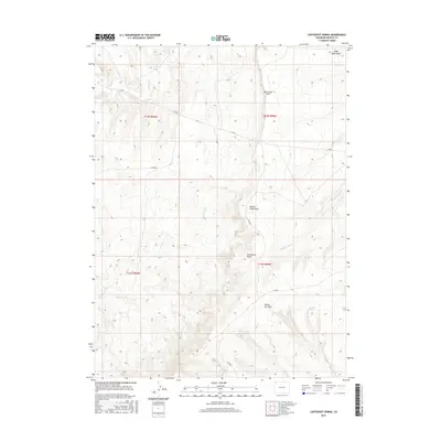
2016 Map of Coffeepot Spring
USGS Topo · Published 2016About this map
Vermillion Bluffs dominate this high-desert landscape in Moffat County, where a complex network of seasonal drainages and named draws defines the terrain. The presence of Coffeepot Spring provides a critical focal point in an otherwise arid expanse, joined by other water-carved features like Yellow Cat Wash and Powder Wash. This 2016 survey illustrates a largely unpopulated area managed by the BLM, marked by a system of rural county roads such as Co RD 4 and Co RD 67. The geography here transitions between distinct flats and steep incisions, notably Racetrack Flat and the descriptive Beaver Slide Draw. Geologists and land researchers can trace the intricate contouring of the bluffs and the winding paths of ephemeral creeks including Shell Cr and Dry Cr.
Find a feature on this map
17 named features on this map. Tap any name to fly to it.
Don’t see what you’re looking for? This feature index may not catch every label — zoom into the map to look around manually.
Map Details
Editions of this 2016 Coffeepot Spring Map
This is the sole edition of this map. No revisions or reprints were ever made.
Other maps of this area

1954 · Vernal
USGS Topo · 1:250,000

1954 · Rock Springs
USGS Topo · 1:250,000

1958 · Vernal
USGS Topo · 1:250,000

1958 · Rock Springs
USGS Topo · 1:250,000

1960 · Vernal
USGS Topo · 1:250,000

1962 · Rock Springs
USGS Topo · 1:250,000

1966 · G Spring
USGS Topo · 1:24,000

1966 · Hiawatha
USGS Topo · 1:24,000
1968 · Chicken Creek SE
USGS Topo · 1:24,000

1969 · Sheepherder Springs
USGS Topo · 1:24,000