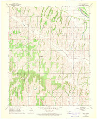
1968 Map of Cogar SE
USGS Topo · Published 1969About this map
Hazel Dell Ch and a nearby Community Hall anchor the rural landscape of north-central Oklahoma in the late 1960s. The terrain is defined by the sharp convergence of the Canadian River and several distinct drainages including Buggy Creek and the meandering Stinking Creek. In the southwest, Jefferson township transitions into the open spaces of Prairie Valley, where the land is cut by the deep channels of West Iodine Creek and East Jack Hollow Creek. Local landmarks like the Center View Cem and Timber Ridge Ch provide specific points of reference for genealogists tracking family ties in Washington township. This survey, based on 1965 aerial photography, captures the intricate network of section roads and unimproved dirt paths that connected these farming and ranching communities just before modernization altered the rural footprint.
Find a feature on this map
20 named features on this map. Tap any name to fly to it.
Don’t see what you’re looking for? This feature index may not catch every label — zoom into the map to look around manually.
Map Details
Editions of this 1968 Cogar SE Map
This is the sole edition of this map. No revisions or reprints were ever made.
Other maps of this area

1893 · Buggy Creek
USGS Topo · 1:62,500

1893 · Minco
USGS Topo · 1:62,500

1904 · Chickasha
USGS Topo · 1:125,000

1945 · Anadarko
USGS Topo · 1:62,500

1954 · Oklahoma City
USGS Topo · 1:250,000

1955 · Clinton
USGS Topo · 1:250,000

1957 · Clinton
USGS Topo · 1:250,000

1957 · Oklahoma City
USGS Topo · 1:250,000

1963 · Oklahoma City
USGS Topo · 1:250,000
1966 · Pocasset
USGS Topo · 1:24,000