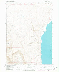
1966 Map of Coglan Buttes NE
USGS Topo · Published 1980About this map
Lake Abert dominates the eastern edge of this terrain, its shoreline punctuated by numerous Springs and an expansive Alkali Flat. The map reveals a landscape defined by dramatic elevation changes, where the western heights descend steeply toward the water. Traces of early movement through this high desert region are visible in the form of the Old Hotchkiss Road (Jeep) and various Jeep Trails that skirt the base of the ridges. Near the shoreline, specific points of interest like a Cave and several bench marks, including BM 4257, indicate the survey's focus on the narrow corridor between the rising buttes and the lake. The incision of Coglan Canyon to the west suggests the primary drainage patterns of this arid environment during the mid-1960s and early 1980s.
Find a feature on this map
10 named features on this map. Tap any name to fly to it.
Don’t see what you’re looking for? This feature index may not catch every label — zoom into the map to look around manually.
Map Details
Editions of this 1966 Coglan Buttes NE Map
2 editions found
Other maps of this area

1955 · Klamath Falls
USGS Topo · 1:250,000

1958 · Klamath Falls
USGS Topo · 1:250,000

1966 · Coglan Buttes NE
USGS Topo · 1:24,000

1966 · Tucker Hill
USGS Topo · 1:24,000

1966 · Coglan Buttes SE
USGS Topo · 1:24,000

1966 · Coglan Buttes
USGS Topo · 1:24,000

1968 · Lake Abert North
USGS Topo · 1:24,000

1968 · Lake Abert South
USGS Topo · 1:24,000

1974 · Lake Abert
USGS Topo · 1:100,000
1984 · Sawed Horn
USGS Topo · 1:24,000