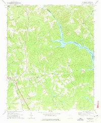
1971 Map of Cokesbury
USGS Topo · Published 1974About this map
Old Cokesbury College stands as a focal point of this Piedmont landscape, reflecting the educational and social heritage of the region during the early 1970s. The settlement of Cokesbury is surrounded by a dense network of country churches and historic burial sites, including Old Tabernacle Cem, St Pauls Ch, and Walnut Grove Ch. The terrain is defined by the winding course of the Saluda River, which feeds into the western reaches of Lake Greenwood, and the junction of Turkey Creek and Little Turkey Creek.
Find a feature on this map
40 named features on this map. Tap any name to fly to it.
Don’t see what you’re looking for? This feature index may not catch every label — zoom into the map to look around manually.
Map Details
Editions of this 1971 Cokesbury Map
2 editions found
Other maps of this area

1892 · Abbeville
USGS Topo · 1:125,000

1948 · Abbeville East
USGS Topo · 1:24,000

1949 · Ninety-Six
USGS Topo · 1:24,000

1949 · Greenwood
USGS Topo · 1:24,000

1950 · Abbeville East
USGS Topo · 1:24,000

1954 · Greenville
USGS Topo · 1:250,000

1958 · Greenville
USGS Topo · 1:250,000
1971 · Cokesbury
USGS Topo · 1:24,000
1971 · Ware Shoals East
USGS Topo · 1:24,000
1971 · Laurens South
USGS Topo · 1:24,000