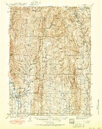
1942 Map of Cokeville
USGS Topo · Published 1951About this map
Cokeville serves as the primary hub in this southwestern Wyoming mountain landscape, situated at the confluence of the Smiths Fork and the Bear River. This mid-century survey illustrates a region defined by high-elevation pastoral and forest management, where the Union Pacific railroad corridor meets a network of historic thoroughfares including the Lander Road, Sublette Trail, and Dempsey Trail. The map documents the extensive reach of the Wyoming National Forest, marked by essential backcountry outposts such as the Smiths Fork Guard Station, Kelley Ranger Station, and Fontenelle Guard Station.
Find a feature on this map
54 named features on this map. Tap any name to fly to it.
Don’t see what you’re looking for? This feature index may not catch every label — zoom into the map to look around manually.
Map Details
Editions of this 1942 Cokeville Map
3 editions found
Other maps of this area

1909 · Montpelier
USGS Topo · 1:125,000

1911 · Montpelier
USGS Topo · 1:125,000

1912 · Randolph
USGS Topo · 1:125,000

1915 · Crow Creek
USGS Topo · 1:62,500

1921 · Afton
USGS Topo · 1:125,000

1936 · Cokeville
USGS Topo · 1:96,000

1939 · Big Piney
USGS Topo · 1:125,000

1942 · Cokeville
USGS Topo · 1:125,000

1942 · Big Piney
USGS Topo · 1:125,000

1945 · Fort Hill
USGS Topo · 1:62,500